 PRESS RELEASE: Geotag Photos 1.1 Released for iPhone - Adds GPS Info to Camera Photos
Prague, Czech Republic - Sarsoft today is proud to announce the release of Geotag Photos 1.1 for the iPhone. By carrying their mobile device along while taking pictures with their camera, users can later identify the location of each photo using the GPS Metadata recorded by Geotag Photos. The real-time clocks of the camera and the app must be synchronized prior to shooting. Sarsoft provides a free online app which geotags each photo by matching the GPS location recorded by the app with the time the picture was taken. Users need only upload the Geotag Photos log, and each picture can be tagged with its exact location before or after it is downloaded into the computer. The web app which geotags each photo is compatible with Mac OS X, Windows and Linux.
Modern, digital cameras take photos by capturing and saving a picture as digital data. In addition to the picture data, most cameras record picture metadata as well: date, time, camera exposure, shutter speed and picture number. However, most cameras cannot record location as well, as this would require a costly, built-in GPS system. Geotag Photos provides a simple solution to this problem. It uses the GPS capabilities of the iPhone to record a log of the user's location at specified time intervals. Sarsoft's web app then uses the uploaded log to match log entries with the time each photo was captured. Geotagged photos are supported by standard Mac OS X photo viewing applications such as iPhoto, or Google's Picasa which is compatible with all major operating systems. The "Places" function in these applications enables the display of location information for every photo, and provides photo retrieval from the map view.
| 
|
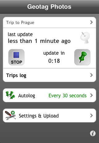
Geotag Photos 1.1 showing a trip being logged.
Screenshot provided by Sarsoft. |
Feature Highlights:
-
Geotag Photos 1.1 enables addition of geospatial metadata to digital photos
-
Exact locations are logged at user-set intervals by application software
-
The app employs the GPS location-finding system of the iPhone
-
Real time clocks of digital camera and mobile device must be synchronized
-
Geotag Photos offers various logging modes, from continuous to manual
-
Sarsoft's web app matches uploaded log entries with time photo was captured
-
Location metadata can be added before or after photos are downloaded to computer
-
Photos can be searched or sorted by location after tagging using wide range of viewing applications - such as iPhoto on Mac OS X or Picasa on Windows and Linux
| 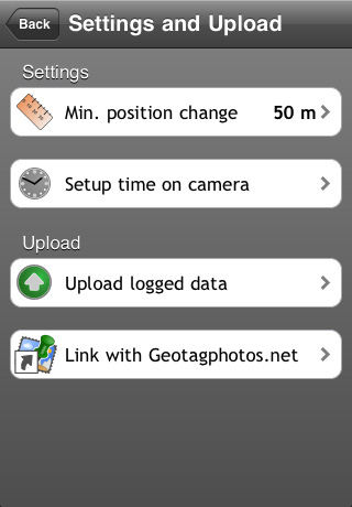 |
The Settings and Upload dialog in Geotag Photos 1.1.
Screenshot provided by Sarsoft. |
Geotag Photos 1.1 includes various logging modes to suit the user and preserve battery life. Continuous logging is appropriate when photographing from a moving vehicle, with exact locations recorded every few seconds. When photographers are moving from location to location at a slower pace, logging intervals can be extended. There is also a manual logging mode, and a street map display.
"Having both the date and the location of every photo adds to the enjoyment of sharing photos with friends and family," commented company Director Jindrich Sarson. "Geotag Photos 1.1 makes it easy to geotag your photos using your iPhone."
| 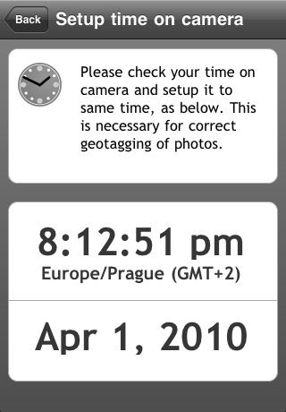 |
Geotag Photos 1.1 relies on your iPhone and camera clocks being closely matched.
Screenshot provided by Sarsoft. |
Language Support:
Device Requirements:
-
iPhone
-
iPhone OS 3.0 or later
-
0.4 MB
Pricing and Availability:
Geotag Photos 1.1 is only $1.99 (USD), and available worldwide exclusively through the App Store in the Photography category. Review copies are available upon request.
| 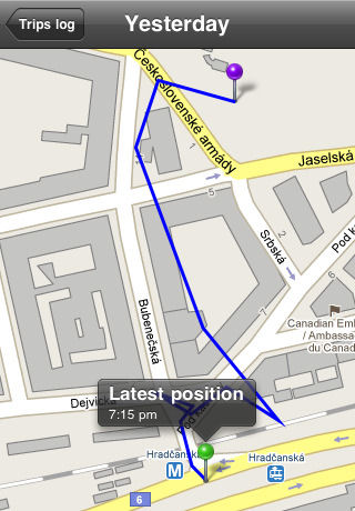 |
Geotag Photos 1.1 showing a trip path for a walk around Prague.
Screenshot provided by Sarsoft. |
Sarsoft
Geotag Photos 1.1
Purchase and Download
You Tube Video
Located in Prague, Czech Republic, Sarsoft is a software development company specializing in applications for mobile operating systems, including Apple iPhone, Google Android and Windows Mobile. The company was founded in 2009 by Jindrich and Jan Sarson, and markets 5 innovative products, so far. Copyright (C) 2010 Sarsoft. All Rights Reserved. Apple, the Apple logo, iPhone and iPhoto are registered trademarks of Apple Computer in the U.S. and/or other countries. Android and Picasa are trademarks of Google, Inc. Windows is a trademark of Microsoft, Inc. Flickr is a trademark of Yahoo, Inc.
###
(First posted on Tuesday, April 13, 2010 at 19:24 EDT)