Public Lab’s Maps are open source aerial images taken from kites and balloons
posted Friday, December 27, 2013 at 1:10 PM EDT
Thanks to Google Earth and its ilk, we have become spoiled for high-quality satellite images of the world around us. But what if you want to take a stab at it yourself — to record your neighborhood from a high-up view? Or what if you want to use open data from those sorts of photos, without being beholden to Google or another big company? Public Lab's Maps project is just that, open aerial data and images that were recorded using balloons and kites, and that absolutely anyone can contribute to.
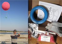
While drone photography may be taking off, buying a drone is out of the price range of many people, where a more low-tech option might be preferable. The Maps project has a full set of tutorials on how to do it yourself, including the option to assemble all the pieces on your own, or buy a balloon kit to get you much of the way. After that, they recommend crafting a housing for your camera from a soda bottle, and sending the whole rig up on a line. Once you've gathered all the photographs, you have to stitch them together, and you can submit them to Public Lab in order to get them added to the site — or you could just keep them yourself for your own interest.
Given the ubiquity of Google's satellite view, what's the advantage of sending up a balloon or kite on your own? Google only refreshes its images infrequently, so this technique is powerful for tracking new and rapidly changing situations. As Public Lab has pointed out, it's been used to disasters like the BP Oil Spill, or temporary situations like Occupy Oakland. Since it's comparatively low tech, you can get higher than most off the shelf drones can go, and have to worry less about it crashing into crowds below.
So if you want to map your neighborhood park, are looking for a good science project, or just want to contribute to the wealth of knowledge in the world, Public Lab's Maps project seems to be an excellent way to do it.
(via Metafilter)