TravelByDrone plots drone footage on a map for fly-over views around the world
posted Monday, March 23, 2015 at 4:34 PM EDT

Meet TravelByDrone, a website dedicated to providing a geographically-based collection of drone videos from operators around the world.
Built on top of Google’s map data, TravelByDrone allows viewers to view the globe via drone footage using geotagged video, uploaded by users to YouTube.
The interface is relatively straightforward, albeit slightly overwhelming at first. Using the ubiquitous ‘pin’ icon, videos are tagged on the map, with the pin turning into a circle if there is more than one video within a designated geographical location.
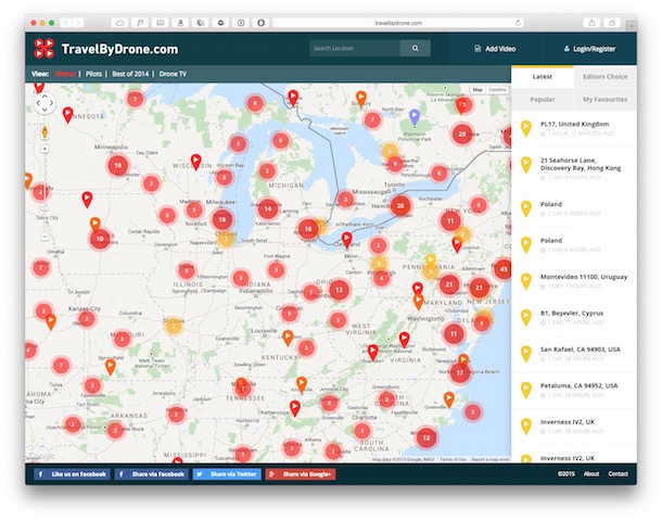
In addition to the collection of videos currently on the site, there’s a sidebar on the right that contains lists of the ‘Latest,’ ‘Popular,’ ‘Editors’ Choice’ and ‘My Favourites’ videos, the last of which can be used to collect, well, your favorites.
If you’d like to contribute your own drone footage, you can do so with or without using an account. To upload, you simply pinpoint the location where the drone footage was taken, paste in the YouTube/Vimeo URL and enter your email address.
Browsing through the footage can be slightly time-consuming as you quickly get lost going from one to another, so if you’re at work you might want to just bookmark the site for them you get home. If you’re at home or don’t care about productivity, head on over to TravelByDrone.