California to use NASA satellite imagery to prepare for future droughts
posted Friday, February 28, 2014 at 8:28 AM EDT
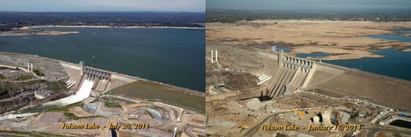
Since late fall of 2013, California has been experiencing a terrible drought that turned much of the state into a wasteland. One composite image released by the California Department of Water Resources dramatically sums up the situation. It shows the Folsom Lake reservoir near Sacramento in July 2011 and in January 2014, and the difference is staggering. While in the July 2011 image the reservoir was at 97% of its total capacity, in the January 2014 image it is down to 17%. The situation is similar in other parts of California as well.
With little to no precipitation up until February, there is not a lot you can do about the lack of freshwater. In order to keep its inhabitants and water-reliant businesses supplied, as well as help those that are in financial need due to the drought, the state of California is going to invest US$687.4 million into a drought-relief package, according to the L.A. Times. The goal is to provide drinking water to those communities suffering most severely from the drought as well as improve water conservation and irrigation systems, among other things.
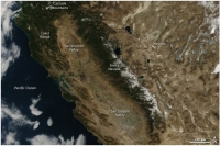
Other measures with a less immediate effect are taken as well, though, in order to be able to better deal with seasonal droughts in the future. The California Department of Water Resources has teamed up with NASA and will be using satellitle data to monitor snowpack and groundwater levels, predicts storms, and even track fields that are not being planted, or land sinking due to excessive groundwater pumping. The long-term goal of this research is to be able to avoid a lack of water as severe as this year's in the future.
So when the NASA's budget is up for debate the next time, maybe we should all take a deep breath and think about what the agency is actually doing. It's not all about building rockets and sending people into space. It's also about solving actual real-world problems like this one. And for us here at Imaging Resource, it's all the more noteworthy that the digital imaging technology employed in NASA's satellites is contributing a significant part to assuring that future droughts can be dealt with effectively.
(via The Verge and Business Insider)
Title image credit: NASA Earth Observatory