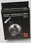
A BARGAIN AT UNDER $150
Macsense Geomet'r --
Geotagging for Nikon dSLRs
 By MIKE PASINI
Editor
The Imaging Resource Digital Photography Newsletter
Review Date: July 2007
Geotagging -- or the inclusion of positioning location in an image file's Exif header -- is the feature of the year. While cameras with receivers built into them are still rare, add-on receivers are becoming a hot accessory. And if the camera already has GPS support (like Nikon dSLRs through the remote 10-pin terminal connectors), all the more reason to start shopping.
There are several ways to get GPS data into your Exif headers. But the general idea is that a receiver communicates with the GPS satellites to find out where you are when you take the picture. It stores that information either in the image file (if the camera supports GPS data through a physical connection) or internally (for syncing via USB later on your computer).
Eye-Fi (http://www.eye.fi) has announced a version of its WiFi SD memory card that the company claims can do geotagging. The Eye-Fi Explore, though, uses WiFi location data supplied by Skyhook Wireless to add geotags. But that's not quite the same thing.
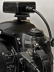
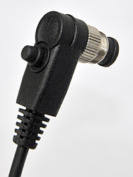
Mounted. Geomet'r is attached to the D200's hotshoe and connected to the 10-pin remote port.
Once you've got GPS data in your images, you use an application or a service to map the location of your images.
The Global Positioning System, developed by the U.S. Department of Defense, is a satellite-based navigation system with at least 24 medium-Earth-orbit satellites that can tell a GPS receiver where on Earth it is using microwave signals.
GPS satellites circle the earth twice each day on very precise orbits. A GPS receiver compares the time a signal was transmitted by a satellite with the time it was received to tell how far away the satellite is. By comparing multiple signals, the receiver can calculate its exact location using a method called triangulation.
In 1982, President Ronald Reagan issued a directive making the system available for civilian use at no charge. All you pay for is the receiver to communicate with the system. That has led to the development of GPS devices that use the system in navigation, map-making, land surveying and other activities that need to know a precise location. Which is why we've begun to see cameras and camera devices that can collect GPS data and associate it with particular images.
THE GEOMET'R | Back to Contents
The $145 Geomet'r GPS receiver is one such device, a GPS reciever designed to tap into the built-in GPS support of the Nikon D200, D300, D2Hs, D3xs, D3 and the Fujifilm S5 Pro.
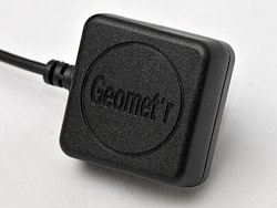
Receiver. The receiver is quite compact and light.
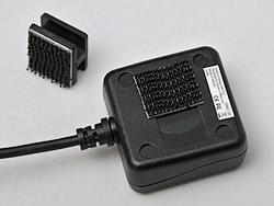
Assembly. Just attach a 3M patch to the bottom of the device and the top of the hotshoe mount.
It consists of a 1.5-inch square and 0.75-inch thick waterproof GPS receiver with a built-in antenna and a power and data cable that attaches to the data port of those cameras. The low-power receiver (with a built-in rechargeable battery for memory and Real Time Clock backup) uses a very small SiRF Star III GPS chipset to capture GPS data from any of 20 parallel satellite tracking channels, about the practical limit at the moment. It also includes a built-in WAAS/EGNOS demodulator to improve accuracy and performance.
INSTALLATION | Back to Contents
Installation is so simple even an Earthling can do it. You attach a Projovian plastic hotshoe mount to the GPS receiver's underbelly using a couple of 3M Dual Lock patches. Beware, though, of the LEDs under there. Then slide the receiver into your camera's hotshoe and plug the data cable into your camera's 10-pin remote terminal connector. To turn the device on, you press a small Power button built into the 10-pin plug on the cable.
Plug. The power switch is on the back of the plug.
It takes about 42 seconds to start the device up when cold, 38 seconds if you just shut it down and one second to wake it up. Our experience was roughly that.
A software CD compatible with Mac OS X 10.3 and later or Windows XP/Vista is also included. The Geomet'r application included on the CD can display a folder of images using Google Map if you're connected to the Web. It simply makes use of the information retrieved by the Geomet'r hardware and recorded in each image file by your camera's firmware.
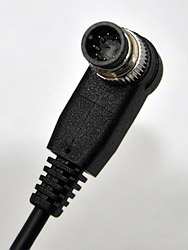
Plug. The pins to mate with the Nikon 10-pin remote connector.
So you don't need software on your computer to merge the GPS data captured by the device with the images captured by your camera. The receiver grabs the longitude, latitude and altitude of your location when you fire the shutter and the camera records it in the Exif header of the image on the card when it gets it from the receiver.
ON A D200 & D300 | Back to Contents
We used the unit on both a D200 and a D300. Installation and behavior was identical.
To connect the cable to the remote terminal, unscrew the cap from the port on the camera and put it in your safety deposit box. Then align the plug at a four o'clock angle and gently pop it in. You can twist it a bit to find the correct alignment before pressing it gently in to seat the pins. Once you've got it seated, screw the metal lock into the camera to secure the connection.
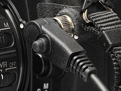
Cable Connection. Note the power button pointing forward.
Next, turn on the camera and push the Power button on the data connector to turn on the receiver. It will flash a red LCD on the right side of the unit as it warms up. When it finds a GPS signal, it will stay solid red.
The LED, which can be hard to see outdoors, isn't your only indicator, however. On the camera, a small GPS icon flashes to the left of the battery icon when the red LED is flashing. It stays on solid when the red LED is solid, so you can just read the LCD icon for your receiver status. Flashing means the device is trying to find a signal. Solid means it will record GPS data with your image.
If you turn the receiver off, it can take a minute to find enough satellites for a reading. But you can leave it on once it has synced, just turning the camera on and off as usual. If you do that, the GPS remains synced so there's no noticeable delay when you power up the camera again.
The receiver is small but it's large enough to block the full elevation of the flash unit. When you mount the receiver so its back end is flush to the back of the camera (so you can use the viewfinder without obstruction), it blocks the pop-up flash.
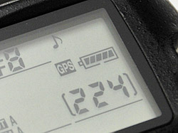
Sync. Note the small reversed 'GPS' icon to the left of the battery indicating sync with the satellite system.
There is a solution to that though. Extra mounting pads are included so you can attach one to your camera strap, freeing the pop-up flash. Orientation doesn't really matter because the unit uses a very sensitive chip antenna.
At first we thought the hot shoe mount should be part of the housing, not Velcroed to it. But when we were handling multiple cameras and resting our forearm on the Geomet'r, we were glad it was able to release itself from the mount. It isn't so much that it falls off, but it does tear away if necessary.
We were able to get a signal both outdoors and indoors. And to record GPS data with the camera held in either the horizontal or vertical position.
While the GPS data is recorded to the Exif header of the image, you can retrieve it while your card is still in the camera. You simply cycle through the display screens using the Down arrow until you come to the GPS display.
EXIF GPS DATA | Back to Contents
The Geomet'r only works with some Nikon cameras because it takes advantage of the Nikon 10-pin interface and built-in GPS support to deliver GPS data that the camera can append to the Exif header of the image file.
GPS data was indeed written directly to the file. Some GPS devices, like the Geotate Kato (http://www.geotate.com), require you to sync a data file written to the device with the image files when you import the images to your computer. It also doesn't calculate position but just stores the raw GPS data for processing later on your computer. That minimizes power draw and makes response time much quicker than the GPS device you might be familiar with from your car's dashboard. But it's another step.
The Geomet'r, however, passes the GPS data to the camera, which knows how to write the data to the image file at the time of exposure without any noticeable delay. There's no step two.
Following is a sample of the GPS data taken from the Exif header (and retrieved using Exiftool by Phil Harvey):
- GPSVersionID: 2.2.0.0
- GPSLatitudeRef: North
- GPSLongitudeRef: West
- GPSAltitudeRef: Above Sea Level
- GPSAltitude: 25 m
- GPSTimeStamp: 21:54:00.8
- GPSSatellites: 03
- GPSMapDatum:
- GPSDateStamp: 2008:06:26
- GPSDateTime: 2008:06:26 21:54:00.8
- GPSLatitude: 37 degrees 44' 33.60" N
- GPSLongitude: 122 degrees 27' 22.80" W
- GPSPosition: 37 degrees 44' 33.60" N, 122 degress 27' 22.80" W
Although the data has been formatted for display from the actual raw information recorded in the file, several of the tags could use a little explanation:
GPSLatitudeRef appears in raw form as either N for North or S for South. We're in the northern hemisphere (above the equator), so N would be right. Likewise GPSLongitudeRef can be either E for East or W for West. We're west of the Greenwhich meridian, so that makes sense, too.
The tags GPSLatitude and GPSLongitude report our actual position.
GPSAltitudeRef, in raw form, can be either 0 for above sea level or 1 for below. You're only reading this because we maintain a position above sea level.
GPSAltitude measures our height above sea level based on readings from several satellites.
GPSSatellites indicates the number of satellites used for measurement.
The altitude accuracy of GPS devices is often compromised by the device's view of the sky. Without a clear and unobstructed view, the altitude can be off significantly because it limits the number of satellites that can inform the calculation. It's generally less precise than position data but even under the best of circumstances it can be off by as much as 50 feet 95 percent of the time.
Our initial shots (all of which reported 25 meters) were taken without a clear view of the sky, however, so this value is quite far off. It's the equivalent of 82 feet, whereas our altitude is closer to 500 feet.
Here the clue is the three satellites that were used. That's enough to calculate latitude and longitude but you need at least four to calculate altitude as well.
Delays are sometimes experienced from both humidity and atmospheric conditions. Our first shots were taken after a number of regional fires had noticeably filtered our daylight into a strange orange glow. But the Geomet'r didn't seem sluggish at all. If it weren't for the cable, we'd have forgotten it was there at all.
Software. Hybrid satellite/street map.
Our second trip with the Geomet'r was a hike up the highest hill in San Francisco, whose elevation we did happen to know. That day, we tapped into between seven and eleven satellites and got much better altitude information, even indoors. At home our 25 meters measured 171 (561 feet) and Mt. Davidson, which tops out at 282 meters scored 272 meters where we sat down near the top. Accurate altitude measurements in our hilly neighborhood required about nine satellites.
We should point out that the position data is not representative of the image itself but of where the camera was located when the image was captured. With a long lens, that can be confusing when you're reviewing images. A shot of Twin Peaks from Mt. Davidson is going to place the location at Mt. Davidson, not Twin Peaks.
Speaking of Twin Peaks, we just had to hike up to each peak to see which one was taller. No matter what the inaccuracy of the reading, it would be reflected on each peak. So which one is taller?
With 11 satellites reporting, we can report that the southern peak measured 276 meters while the northern peak measured just 251. That's 905.5 feet to 823.5 feet. Officially, the peaks are 922 feet.
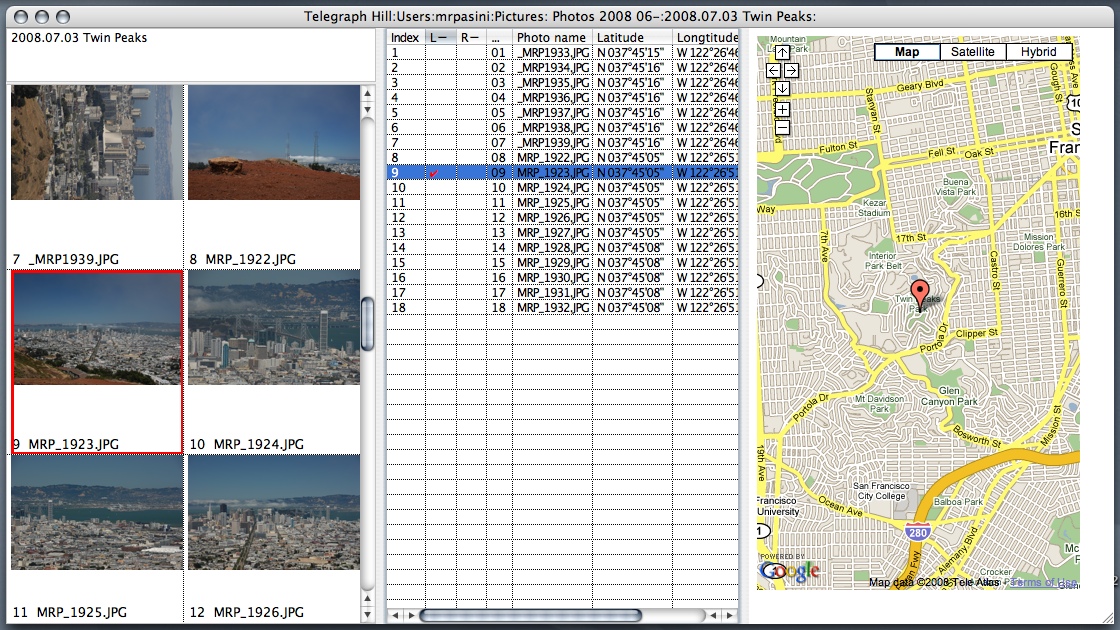
Software. Street map.
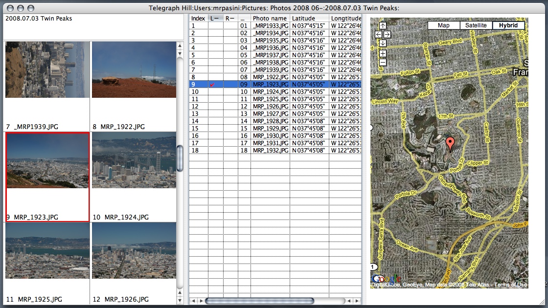
The Geomet'r application is a quick and easy way to see where your pictures were taken. Point it to a folder of GPS-encoded images and it will open a window with a thumbnail in the left pane. In the middle pane it will display a spreadsheet-like index listing the filename, camera time, GPS time, latitude, longitude and altitude of each shot. And in the right pane it will show a Google map if you're connected to the Internet.
You can configure the display somewhat as well. We elected not to show anything but latitude, longitude and altitude in the listing so we could have roughly equally-sized panes.
Clicking in the L column showed the pin-point location for any image on the Google map (which can be satellite or hybrid as well). Clicking in the R column painted the area in which the images were taken blue. Each column can be sorted by clicking on the title bar.
And Flickr (http://www.flickr.com), the photo sharing site, has been supporting GPS data for almost two years now. The site hosts over 42 million geotaggged photos already.
PRICE & AVAILABILITY | Back to Contents
You can pick up one of these little wonders right now directly from Macsense (http://macsense.com) or Amazon.com for $149.99. To appreciate that price, Nikonians, the Nikon user group, sells the Solmeta Digital Photo Locator with the same chip in a slightly bigger housing that includes a remote control connector for $329.
The Geomet'r took just a minute or two to attach to our camera, synced with multiple satellites in another minute and seamlessly added GPS data to the Exif headers of our JPEG images. After turning it on and waiting for the sync signal, we didn't have to give it a thought.
It couldn't be simpler but part of the credit for that is Nikon's GPS-ready dSLRs, which recognize GPS data being sent through their 10-pin connectors. When we asked Macsense if they were working on a version for other popular dSLR brands, they explained, "To develop a GPS adapter that works universally with all cameras is the holy grail of GPS adapter making. It is not easy because the camera does not have a direct input to the Exif data at the time of the shot."
But Nikon owners can take advantage of this trouble-free, compact unit for half the price of competing units. Outright prolonged applause.