| Back To News |
Geotagging, without the privacy issues: Canon offers a solution
posted Friday, May 18, 2012 at 1:42 PM EDT
 Geolocation can be great for keeping track of where you've been, and what photos you've shot on your travels, but it also has a dark side. Location-aware cameras are increasingly common, especially in smartphones. If you don't know that your specific device is capable of geotagging (or perhaps, incorrectly believe that the function is disabled), that can lead to you giving out much more personal information than you intended when you share your images. If you read our recent article, "Geotagging: the silent killer, says US army", you'll be aware of just how dangerous that can potentially be.
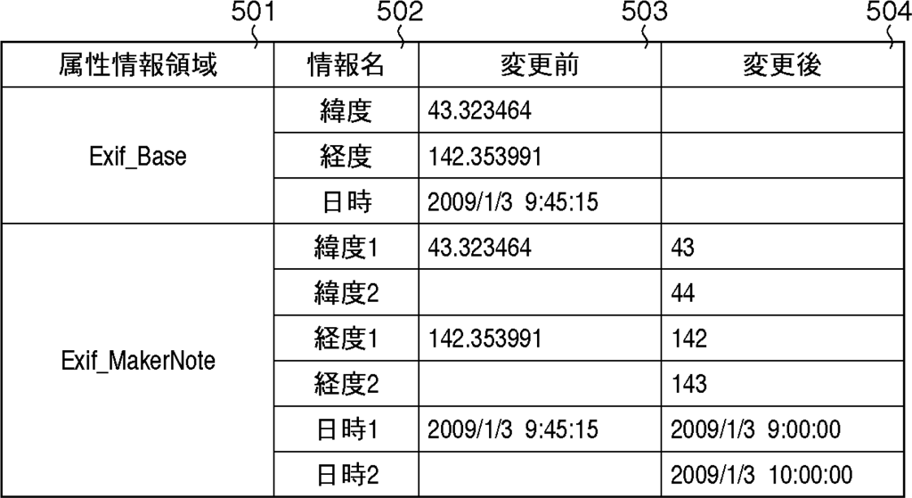
Earlier this month, the Japan Patent Office approved a patent application by Canon Inc. that shows the company hard at work on solutions. Spotted by Japanese engineering blog Egami, the patent suggests a method for increasing privacy while still retaining some geolocation information, simply by reducing the precision. In the image below from the patent, the left column (marked '503') shows the actual capture location and time for an image as stored in its EXIF header. On the right, this information is replaced by the outer bounds of an approximate area in which the image was captured, along with the hour of capture, but no more specific information is given.
 |
|
This table from Canon's patent demonstrates one manner in which location and time information can be obscured to protect privacy, while still providing some useful information for the photographer. Image provided by Japan Patent Office. |
Elsewhere in the document, alternate methods of obfuscating the precise location are suggested. One method is to provide an exact position rather than a a bounding box around the location, and then simply round the latitude and longitude figures to a lower precision, such as to one decimal place. Alternately, the patent suggests converting the latitude and longitude to a place name, and storing this in the EXIF header.
Canon filed for the patent in October 2010, and it was granted on May 10th. Like any patent, there's no guarantee that the techniques described will make it into a final product, but they're an interesting indication into the thinking at Canon with respect to geolocation privacy concerns.
 |
|
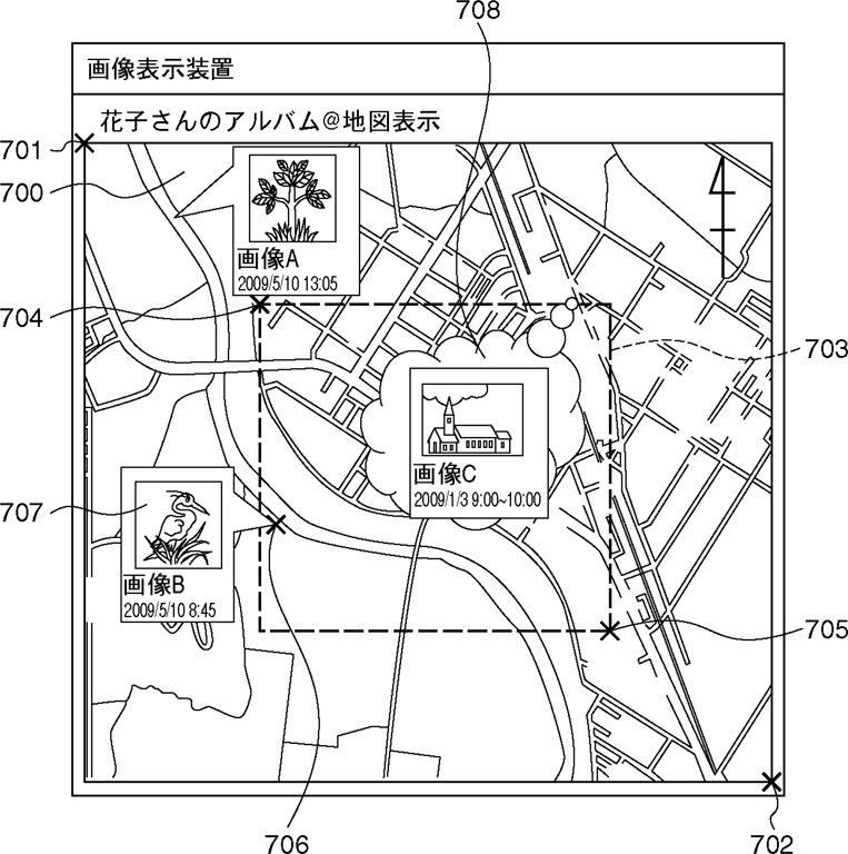
Another image from the patent, showing how a bounding box (the dashed square) could be used to provide an approximate capture location, without giving too much detail. Image provided by Japan Patent Office. |
(via Canon Watch)