 Most Significant New Technology from PMA - NXP's SnapSpot GPS
By
Dave Etchells
(Monday, March 19, 2007 - 16:14 EDT)
Every year I look for the piece of technology at PMA that'll have the biggest impact on the photography marketplace over the next year or so. This year, that honor goes to NXP Software's "SnapSpot GPS" technology. You heard it here first: Two years from now, a lot of digicams (and even cell phones) will have GPS-based geo-tagging capability built right in!
Every year at PMA, I look for the technology that best gives a glimpse over the horizon at what's coming for the digital camera market in the months and years ahead. This time, I wasn't really seeing much that seemed very revolutionary, and had almost despaired of my search. - Until, that is, I came across NXP Software, and their "SwGPS SnapSpot" technology.
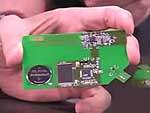
This is actually the technology behind the Jobo GPS gadget that we reported on at the very beginning of the show, a clever gadget that attaches to any camera's flash hot shoe, grabbing a "snapshot" of GPS data whenever you press the shutter button. Software later marries the GPS data with the JPEG file headers (or with the RAW files, via a "sidecar" folder). That much isn't exactly news, Sony makes a GPS gadget that does much the same, that we saw at last year, and we showed similar functionality from Samsung in another video from this year's show.
What makes the Jobo solution so unique is that it consumes almost no power, running for upwards of a year on a single lithium coin cell.
It wasn't until I finally met up with the folks from NXP Software, who developed the technology used by Jobo, though, that I found out how truly unique their solution was. It's clear that this could have a huge impact on the entire digital camera market.
For the real techies, I taped an extensive two-part video interview with Paul Gough, NXP's Product Marketing Manager, that goes into all the nitty-gritty of just how they managed to pull off this feat. (It's in two parts because it was too long to fit into a single YouTube video clip.)
For those less technically infatuated, the simplified version of the story goes as follows: Rather than try to do all the processing that's normally required for computing a GPS fix, the NXP device simply takes a digital "snapshot" of the raw GPS data whenever it wakes up. This only takes a tenth of a second, and consumes almost no power. Later (back on your computer), their client software queries a server they maintain, that's continuously logging the detailed "ephemeris" data for all 32 GPS satellites. This is the data that tells exactly where each satellite is located in space at all times. Figuring out which satellites are in view, synchronizing with them, and downloading their ephemeris data is what takes typical GPS systems minutes to handle: This is why it takes so long for your GPS to start up and deliver the first position fix.
By offloading all the satellite tracking and computation to your host computer (when you download your images), NXP is able to reduce the "footprint" of their hardware to an incredibly tiny area (5x5mm in production versions), and to grab the needed data and go back to sleep very quickly.
The bottom line is that the NXP geo-tagging solution is incredibly small, incredibly cheap ($2-4 per camera, in very high production volumes), and incredibly power-efficient: You could grab hundreds or thousands of GPS snapshots for the same amount of energy required to capture and view a single digicam image.
It's important to note though, that this solution only works for geo-tagging images and other non-real-time applications, because it only tells you where you've been, rather than where you are at any given moment. The GPS results aren't available until you get back to your computer and can access NXP's server to look up the ephemeris data. (Cell phones or digicams with powerful enough internal processors and internet access could sidestep this limitation though.)
The NXP GPS solution is just in prototype, "reference design" stage at present, but appears to be working very well.
This strikes me as a really significant development for the digital camera field. Given the typical digicam design lead-times of 18 months or so, I'd say we can expect to start seeing this technology in consumer digicams somewhere in the second half of 2008, or at worst early 2009. With camera manufacturers having to work harder and harder to find useful features to differentiate themselves from the competition, GPS-based geotagging looks like the must-have feature for the next generation of digicam designs! -- Remember, you heard it here first! :-)
|